Getting There
From Rome by car
Click here for Google Maps, Rome to CDP
It'a about a two-hour drive from Leonardo da Vinci airport (Fiumicino) to Citta' Della Pieve.
The link above is useful mainly for the map, NOT for Google's byzantine directions. I recommend you do NOT try to follow them either for getting from the airport to the "A-1" autostrada (freeway) that goes north to Firenze (Florence), or for your route at the other end when you approach CDP.
For the airport to A-1 part, ask the rental people when you pick up your car; their advice will probably be a lot more useful than Google. The overview is: You take a spur road from the airport to the "GRA" (acronym for the "ring road" that encircles Rome), then proceed around the GRA in a clockwise direction until you exit onto the A-1. The key is the follow the signs to Firenze pretty much from the beginning until you are certain that you are on the A-1. The only caveat (other than: stay alert!) is to avoid one or two occasions where there are "Firenze" exit signs leading to alternate, non-freeway routes.
Then you stay on the A-1 (FYI, it's a toll road) almost the entire way (about 100 Km), exiting at the town of Fabro. By the way, on this part of the A-1, the freeway has a scond name, "E-35" (because the road is part of the EU freeway system).
At Fabro, after paying the toll, turn Left onto the main road. Go about 1 Km and turn Left again; at this turn there may be a sign to "Ponticelli" but I'm not sure. This road heads north and parallels the A-1, and you go about 8.5 Km on it until you arrive at an intersection with a gas station in front of you. Take a Right, and continue straight through the roundabout and the tiny town of Ponticelli. Follow this road all the up the hill, and when you reach the top, turn Left. You have arrived in Citta' Della Pieve.
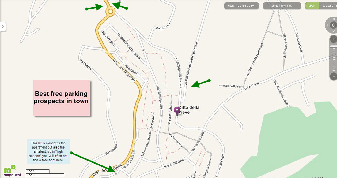
Go straight and you will be following the main road around the town in a clockwise direction. You will be on the road shown in orange on the second of the two little maps on this page. I recommend that initially, you park your car in one of the two free lots indicated by the two green arrows at the top of that map (adjacent to the roundabout), and then walk into the town center.
It'a about a two-hour drive from Leonardo da Vinci airport (Fiumicino) to Citta' Della Pieve.
The link above is useful mainly for the map, NOT for Google's byzantine directions. I recommend you do NOT try to follow them either for getting from the airport to the "A-1" autostrada (freeway) that goes north to Firenze (Florence), or for your route at the other end when you approach CDP.
For the airport to A-1 part, ask the rental people when you pick up your car; their advice will probably be a lot more useful than Google. The overview is: You take a spur road from the airport to the "GRA" (acronym for the "ring road" that encircles Rome), then proceed around the GRA in a clockwise direction until you exit onto the A-1. The key is the follow the signs to Firenze pretty much from the beginning until you are certain that you are on the A-1. The only caveat (other than: stay alert!) is to avoid one or two occasions where there are "Firenze" exit signs leading to alternate, non-freeway routes.
Then you stay on the A-1 (FYI, it's a toll road) almost the entire way (about 100 Km), exiting at the town of Fabro. By the way, on this part of the A-1, the freeway has a scond name, "E-35" (because the road is part of the EU freeway system).
At Fabro, after paying the toll, turn Left onto the main road. Go about 1 Km and turn Left again; at this turn there may be a sign to "Ponticelli" but I'm not sure. This road heads north and parallels the A-1, and you go about 8.5 Km on it until you arrive at an intersection with a gas station in front of you. Take a Right, and continue straight through the roundabout and the tiny town of Ponticelli. Follow this road all the up the hill, and when you reach the top, turn Left. You have arrived in Citta' Della Pieve.
Go straight and you will be following the main road around the town in a clockwise direction. You will be on the road shown in orange on the second of the two little maps on this page. I recommend that initially, you park your car in one of the two free lots indicated by the two green arrows at the top of that map (adjacent to the roundabout), and then walk into the town center.
Once you're there...
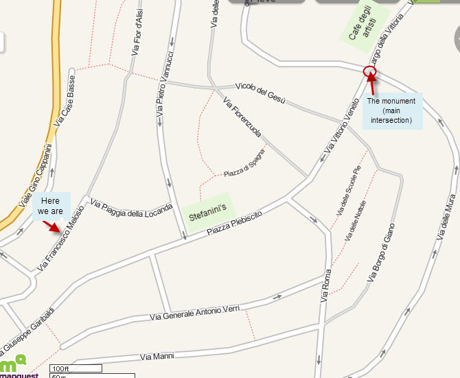
The first map below shows you where the apartment is located in respect to the central streets and a couple of prominent landmarks. The roundabout where the "The monument" and "Cafe degli artisti" are located is the main intersection of the town. Cafe "Stefanini" is the piazza where the duomo (cathedral) is situated. Via Pietro Vannucci is the main commercial street. Everything is a couple minutes walk, or less, from everything else.
If you will have a car: there is no parking for non-residents in the streets of the town center, and that includes our street. Use the parking areas indicated by the green arrows in the second map below.
If you will have a car: there is no parking for non-residents in the streets of the town center, and that includes our street. Use the parking areas indicated by the green arrows in the second map below.